Rationale
At Jericho Primary School we are geographers! Right from the start children in Nursery and Reception, children learn that geographers study places around them, the earth, land and people. As children develop their understanding of being a geographer, they learn that being a geographer is the study of places and the relationships between people and their environments
We want our children to achieve well in geography as we believe that Geography helps to provoke and provide answers to questions about the natural and human aspects of the world. We want to encourage our children to develop a greater understanding and knowledge of the world, as well as their place in it. The geography curriculum at Jericho Primary School enables children to develop knowledge and skills that are transferable to other curriculum areas and which have our core values of nurture, achievement, respect, adventure and creativity embedded within the learning sequences.
Our Curriculum
Geography is, by nature, an investigative subject, which develops an understanding of concepts, knowledge and skills. It is our intention that pupils become a little more expert as they progress through the curriculum, accumulating and connecting substantive and disciplinary geographical knowledge.
Substantive knowledge - this is the subject knowledge and explicit vocabulary used to learn about the content.
Disciplinary knowledge – this is the use of knowledge and how children become a little more expert as a geographer by “Thinking Geographically”. At Jericho, we have identified the disciplinary knowledge as:
- Locational knowledge: - Builds own identity and develops their sense of place, develops pupils’ appreciation of distance and scale, helps pupils learn about the orientation of the world and how to navigate. Place: the significance of places and what they are like,
- Space: the significance of location and spatial distribution, and ways people organise and manage the spaces that we live in, Scale: the way that geographical phenomena and problems can be examined at different spatial levels.
- Place knowledge – How pupils connect to places and locations and identify themselves within the world e.g. - connection of location and physical and /or human geography processes with personal experience - no object of geographical study can be viewed in isolation
- Human and Physical Processes - explicit knowledge about geographical processes - for example, migration, glaciation, climate change, Environment: the significance of the environment in human life, and the important interrelationships between humans and the environment, Sustainability: the capacity of the environment to continue to support our lives and the lives of other living creatures into the future, Change: explaining geographical phenomena by investigating how they have developed over time
- Geographical skills and fieldwork – Procedural Knowledge - Using maps and globes and collecting first-hand evidence.
We have designed our curriculum so that children:
Build upon prior learning: For example, in the EYFS, pupils learn about their locality and immediate environment. This is revisited in Year 1 as children begin to study their locality – Whitehaven in more depth. This makes it easier to cognitively process. Children revisit this as they move on to learn about their place in the United Kingdom. Later on, in KS2, more detailed knowledge of the area is gained by learning about villages, towns and cities. Each unit of work builds on previous learning.
Cumulate Knowledge: Our curriculum is built on the principles of spaces, places, scale, and human and physical processes. These principles are built one step at a time, revisited over time to ensure that they culminate in out end of unit, year and key stage outcomes.
Build on their Substantive Knowledge: Our curriculum equips pupils to become ‘more expert’ with each study and grow an ever-broadening model of the subject. We have identified clear knowledge that is to be taught for each unit of work. This knowledge is carefully sequenced so that each piece of knowledge builds on the previous piece of knowledge so that children become ‘more expert’ in the subject. Golden nuggets of knowledge have been identified clearly in each lesson so that teachers can easily check whether children know more and remember more.
Develop their Geographical Vocabulary: Geographical vocabulary is planned sequentially and cumulatively from Early Years to Y6. High-frequency, multiple-meaning words (tier 2) are taught and help make sense of subject-specific words (tier 3).
Knowledge Retention: Our geography curriculum is planned so that the retention of knowledge is much more than just ‘in-the-moment knowledge’. The cumulative nature of the curriculum is made memorable by the use low stakes quizzes that help children to remember the golden nuggets.
How our Curriculum develops
EYFS
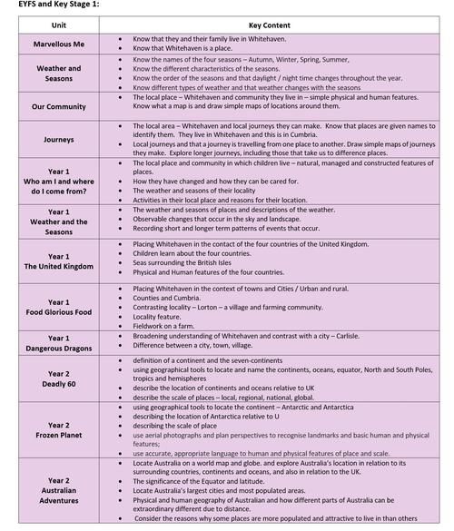
The importance of starting a child’s geography is paramount. Our curriculum is designed to give children the vocabulary they need to describe their surroundings, investigate the immediate locality and begin to make connections with places further afield. Children enter school knowing their homes, garden and local streets. As they move through the early years we extend this further by looking at their local community of Whitehaven and looking at places familiar to them that are further afield. They explore how places change and look at how the seasons change and how places change over longer periods of time. Children start to learn about the world around them. We develop children’s investigating, observing and recording skills, encouraging them to ask questions about why the world around them is as it is builds a good foundation for future geographical enquiry.
KEY STAGE 1
The sequence in KS1 helps young children to develop a sense of place, scale and an understanding of human and physical geographical features. Throughout KS1, pupils learn more by studying and identifying Human and physical features of places. Initially, children build on their knowledge of their own locality from the Early Years. They build a strong sense of their place in the locality. They identify features of the local area. This place and space knowledge is then developed by looking at how places are interconnected. Children learn about their place within Whitehaven, Cumbria, England and then the United Kingdom. Children learn about the contrasting locality of Lorton – a village in Cumbria and finally in Year 1 they learn about the city of Carlisle. As children move through Year 2 they learn more about their place in the wider world. Children study the orientation of the world by acquiring and making locational sense of the 7 continents and 5 oceans of the world. They extend their knowledge and study of the continents by looking at the Artic and Australia. These two studies also offer rich opportunities to know, compare and contrast different cultures on two continents using the consistent thread of human and physical features.
Children use of maps, globes and atlases to support their thinking about the big ideas that explain how we know where a place is, and how to locate it.
Fieldwork and map skills are further developed with a study of the local area, using the cardinal points of a compass. Pupils retrieve and apply knowledge about human and physical features in their local context. OS maps are introduced to pupils in KS1 using Digimap for Schools. Simple keys and features are identified and mapped locally to help begin to understand place, distance and scale.
LOWER KEY STAGE 2
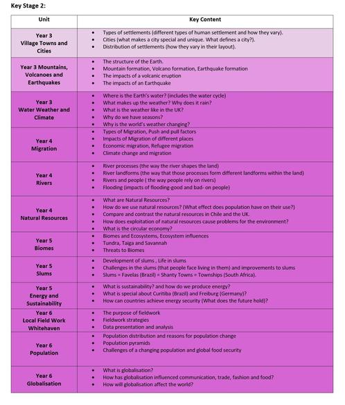
As pupils begin Key Stage 2, they begin to develop further their understanding of Place by learning about settlement types and settlement patterns. Fieldwork and map skills are revisited with the intercardinal points of compass points being introduced to elaborate on the knowledge pupils already have around cardinal points. Complementing studies on location and position is the focus on the Water cycle. They develop their knowledge of physical geography by conducting in-depth studies of Volcanos and Earthquakes and making connections about how the environment has been shaped, as a result.
Pupils elaborate and expand their understanding of human and physical features and apply it to the study of Rivers. Substantive knowledge is acquired and used to apply their new understanding to mapping and fieldwork skills. Children, develop their knowledge further of human geography by investigating Migration and how humans use the Earth’s Natural Resources. These studies help pupils develop their knowledge of geographical patterns across the world.
UPPER KEY STAGE 2
The study of Energy and Sustainability builds upon children’s understanding of how human geography. They use this to develop their knowledge of the world further by looking at Biomes and Environmental regions. This builds upon world locations, building a more complex understanding of both physical and human geography. World countries and major cities are located, identified and remembered through deliberate and retrieval practices, such as low-stakes quizzing. In upper KS2, the study of 4 and 6-figure grid references supports prior learning of reference systems and brings an increased accuracy to mapping and fieldwork skills. More advanced mapping skills using OS maps are studied and applied and children develop their use and understanding of more complex maps such as thematic, distribution map and map projections.
As children move through Upper Key Stage Two, they develop their ability to reason and explain the effect of change on a place. They draw on their knowledge of the world by studying Slums and build further on place knowledge by looking at how life is different for different people. Finally, children build on their knowledge of the wider world by studying globalisation and population. These units help pupils make connections between settlements and physical or human features. Children consider settlement, trade and economic activities and consider how globalisation has changed the world that they live in.
Key content of the curriculum units